Relative dating is basic to chronology. It is ordering of events in the absence of any written record or evidence. Relative chronology is important in reconstructing prehistoric archaeology / palaeoanthropology. In relative dating the duration of the event is unknown, so also the elapsed time between events is very difficult to determine. Furthermore, the temporal distance between any past event and the present cannot be determined. All of these deficiencies can be overcome when relative time is transformed into an absolute scale.
(a) Stratigraphy
Stratigraphy is the study of layered deposits. Stratigraphic study is based on the law of superposition, which declares that deposits, whether of natural or cultural origin, form with the oldest on the bottom of the sequence and each overlying stratum younger, or more recent, than the layer below. Once the strata have been observed from early to late, it is possible to date the artifacts and eco-facts of each layer according to Worsaae’s law of association. This position states that objects, both natural and cultural, found together in the same layered deposit are of the same age. Thus the relative dating of the super positioned deposits also dates their fossil specimens. The law of association is useful not only in the ordering of site historiographies, but also in the construction of local regional sequences.
The terminus post quem
A datable object (such as coins and inscriptions) or datable find (such as a radiocarbon sample from a layer or feature) only gives the date after which the layer or feature was deposited, that is, the so called terminus post quem (Latin phrase meaning the end after which). The basic principle stands behind this term is that any number of datable finds one may come across in any continuous sealed layer.
Among the datable objects, the object of latest date is considered as the terminus post quem. For instance, if one gets a Satavahana, Gupta, Pallava, Chola and Vijayanagara coins in the same layer then the layer or feature is dated to Vijayanagara period, the latest dynasty among them.
The terminus ante quem
The terminus ante quem (Latin phrase meaning the end before which) is when features or layers are sealed by or are cut through by later datable features, the date of this later feature serve as terminus ante quem (that is a date before which the earlier features must have been deposited). For instance, if a series of layers is sealed by a layer of 10th century BCE (dated based on datable material) then all the layers below are dated earlier to 10th century BCE.
The relative date as well as the absolute date obtained in a particular stratigraphical context really helps to date the deposit that is embedded below or above the dated layer.
For the archeologist a “stratified” site is one with distinct archeological horisons, with or without a geologic context. The term “surface” site might be used to describe a variety of things, such as an archeologically un-stratified surface-find or even an ancient open-air encampment now buried by a meter or two of loess or marl. From the archeologist’s point of view, sites may be classified according to their cultural-ecological meaning or according to digging criteria. The earthscientist, interested in providing a stratigraphic date or a geographical-ecological meaning for a site, would naturally use different criteria of classification.
“Stratified” and “surface” sites: The most interesting kind of archeological site for the earth scientist is one found in a direct geologic context, i.e. geologically stratified or geologically in situ. This should not imply that the cultural materials have not been derived, but only that their present location is geologically circumscribed. For the sake of Convenience “Stratified” will here be used in this geologic sense only. “Surface” site will be restricted to materials found at the surface, without geologic context.
According to the basic geomorphological situation or the type of deposits involved, archeological sites can be geologically classified as follows:
- a) Alluvial sites: artifacts, fossils, occupational floors and the like found within former stream deposits.
- b) Lacustrine sites: archeological materials found in former lake beds, in ancient bogs, swamps, or spring deposits.
- c) Aeolian sites: archeological materials found in or under wind-borne sand or loess, or found in relation to features resulting from deflation or wind scour.
- d) Cave sites: archeological materials found in direct relation to erosional or depositional phenomena associated with former coastlines.
- e) Costal sites: archeological materials found in caves with some form of geologic or archeological stratigraphy.
- f) Surface sites: the great mass of scattered archeological materials and sites found at the surface, with little possibility of direct association with any geomorphic event.
Identification of the depositional medium contemporary with or subsequent to an archeological site is vital to the earth scientist. The specific relation of a cultural horizon to a geomorphic event can provide direct paleo-environmental information. This local environmental setting may in turn be stratigraphically linked to regional or worldwide changes of climate.


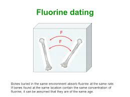
(B) Fluorine Test Dating
Fluorine test dating is another method of relative dating. It is based on the fact that amount of fluorine deposited in bones is proportional to their age. The oldest bones contain the greatest amount fluorine, and vice-versa. The fluorine test is useful in dating bones that cannot be ascribed with certainty to any particular stratum and cannot be dated according to the stratigraphic method. A shortcoming of this method is the fact that the rate of fluorine formation is not constant, but varies from region to region. The quantity of fluorine can be determined either through chemical analysis or with the X- ray crystallographic method.
(C) Nitrogen Dating
Nitrogen provides another measurement of relative age. By contrast to fluorine, nitrogen in bone decreases with the length of time it has been buried. The nitrogen test together with fluorine will provide information as to the relative age of bone specimens. Such techniques are especially important when we wish to establish whether all the bone specimens in a level or of the same age or whether they are of different ages and their association in the level are due to secondary deposition.
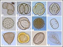
(D) Palynology
Relative dating can also be done on the evidence of floral remains. A common method, known is Palynology (the study of pollen grains). The kind of pollen found in any geological stratum depends on the kind of vegetation that existed at the time such stratum was deposited. A site or locality can therefore be dated by determining what kind of pollen was found associated with it.
Pleistocene Plant Fossils- Pollen Pollen analysis or palynology is one of the important indicators of palaeoclimate and dating in palaeo ecological studies. The basic principle of pollen analysis is that most wind-pollinated trees, shrubs, and grasses emanate pollen in great quantities. The particle size of pollen is on the order of 0.01 – 0.1 mm.’ and the absolute weight less than 10-9 grams. Consequently, pollen grains are readily removed by wind and widely dispersed in the lower atmosphere where the grains are carried in suspension. Distances of 100-250 km. are readily crossed by traveling pollen, and grains may be found up to several kilometers in the lower atmosphere. Pollen density is greatest at elevation of 200 to 500 meters above the ground, and it remains appreciable to elevation of 2 km. Pollen accumulation in any one locality will therefore provide a regional rather than a local crosssection of the pollen-emanating plants present
The annual pollen ‘rain’ in a vegetated area amounts to several thousand grains per square centimeter. A part of this pollen may be preserved indefinitely if oxidation is limited or absent, particularly in dense, poorly aerated sediments or in acidic environments such as provided by bogs or many lake beds. Year after year stratified laminae of sediments, including a small cross-section of the year’s pollen that is preserved, may be laid down under various conditions at a number of localities. Each of these sediments, then, preserves its own chronological and environmental record (Butzer, 1971).
Application of pollen analysis
Pollen analysis may be applied to a broad range of palaeo-environmental problems.
- a) Reconstruction of local vegetation: Careful interpretation of contemporary pollen spectra from neighbouring sites may provide a good picture of local vegetation and ecology. Certain floral elements are characteristics of certain environments, although most genera are distributed rather than more broadly. If species identification is possible and supported by some macro-botanical evidence reconstruction of forest type is possible.
- b) Regional pollen maps: Plotting of data of approximately contemporary pollen spectra over wider areas can be made.
- c) Climate change: Although with considerable qualification, it may be said that specific changes in pollen spectra with time may indicate climate or ecological change at a locality.
- d) Stratigraphic dating: Characteristic pollen diagrams have been described for certain interglacial periods or for the Holocene period in temperate Europe. Such standard profiles are frequently used as dating tools, either within the span of a certain diagram, or as fossil assemblages referring to a particular interglacial interval. Artifactual materials in bog can occasionally be dated according to their position within pollen profiles.
- e) Prehistoric settlement: Forest clearance, burnings, and agricultural colonisation are dramatically recorded in pollen profiles by sudden abundance of NAP, appearance of weed or cereal pollen, and the like. In fact the earliest agricultural settlements in temperate Europe frequently have been first recognised by pollen diagrams, as in the case of Denmark.
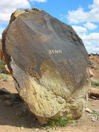
(E) Patination
Stones either buried in the ground or laying on the surface for a length of time undergo chemical alteration. Such alteration, termed patina, is manifest in a milky coloured coating on the surface of the stones. The differences in degree of patination are assumed to represent differences in relative age.
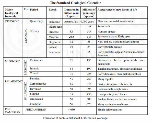
(F) Geological Calendar
The history of the earth is subdivided by the geological calendar. Originally this history was organised by the relative age of the various rock formations that comprise the stratigraphic record of the science of historical geology. Later this relative chronology was converted to an absolute chronology by the use of the various radiometric-dating techniques. The oldest rocks, of Pre-Cambrian age, have been dated to 4.6 billion years ago by uranium-lead radiometric assays.
Younger sub-divisions of the geological calendar are dated in a relative sense by the fossil content of the rock units and in an absolute manner through the broad range of isotopic decay techniques.
The subdivisions of the geological calendar with taxonomic breakdown into eras, periods and epochs are presented in the table. The Cenozoic, the latest era, is the subdivision during which modern forms of life evolved. The Cenozoic era is subdivided into two periods, the Tertiary and Quaternary, respectively the third and fourth subdivisions of the geological calendar. The Tertiary period saw the rise of mammals, including primates during the last 65 million years. The Quaternary is of prime importance to the study of cultural evolution because it is the period of humankind. During the Quaternary, the fossil record shows the biological evolution of humans and their primate relatives over the last two million years.
(G) Glacial Calendar
The Quaternary period of the geological time scale in turn is subdivided into two epochs, the Pleistocene and the Holocene. The Pleistocene is characterised as the “Ice Ages” when pre-modern humans evolved. Fully modern humans, called Homo sapiens in biological terminology, appear at the end of Pleistocene and flourished during the last 10,000 years, epoch called Holocene. The Holocene epoch is the geological interval following the ice ages and hence is often called post-glacial. It has witnessed essentially modern climates and is marked by the appearance of the first agricultural village and ultimately of urban civilisation. The Pleistocene is characterised as an epoch of widely fluctuating climates with world temperature averages ranging between 4º and 5º C below today’s values. During cold climatic episodes the polar icecaps thickened and continental glaciers advanced as snow accumulated at high latitudes, while mountain glaciers formed and advanced in middle latitudes. While water was stored in ice sheets, the world sea level dropped because of the retention of water at high latitudes. Alternately during warm, interglacial episodes of the Pleistocene, the icecaps melted, glaciers retreated, and sea levels rose.
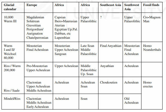
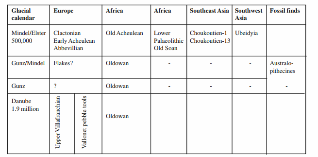
The glacial calendar is subdivided according to oscillation of climates from cold to warm. The cold episodes are called glacial stages. In Europe at least four glaciations have been recognised and named as Gunz, Mindel, Riss and Wurm in Alps mountain region and Elster, Wieschel, Saale and Wardha in Scandinavian region. Three warm climate phases have been identified and named Gunz-Mindel, Mindel-Riss and Riss-Wurm interglacial in southern Europe, and Cromerian, Holsteinian and Eemian in northern Europe. The capitalised glacial stage names are pulses of cold climate with internal variations. These minor oscillations of intense cold are called stadials while the intervening relatively warmer subepisodes are called inter-stadials. Chronological Chart of Pleistocene Period and Palaeolithic Cultures in the Old World
Customarily, the Pleistocene epoch is periodised in a three-fold scheme as upper (late), middle and lower (basal). The Lower Pleistocene is marked by: 1) the first cold phase, 2) the Biber glaciation, 3) the two Donau glaciations, and 4) the Gunz glaciation. The time interval of the Lower Pleistocene period extends from 700,000 to 2.0 million years ago. The Middle Pleistocene contains the Cromerian and Holesteinian interglacial plus the Mindel and Riss glacial stages, according to the terminology of the Alpine-Swiss sequence of Europe. The corresponding glacial stages, Elster and Saale, are advances of the Scandinavian sheet that pushed down from the Baltic Sea onto the north German plains. And finally, the late (upper) Pleistocene epoch is a comparatively short period of time approximately of 100,000 years including the Eemian interglacial and Wurm / Weichsel glaciation and ending about 10,000 years ago with the final retreat of the worlds continental and mountain glaciers. The Pleistocene period in Africa has witnessed the downpour of rains called pluvials. These are named as Kageran, Kamasian, Kanjeeran and Gamblean pluvials corresponding to the glacial episodes of Europe.
These pluvials are alternately represented by inter-pluvials such as Kageran-Kamasian, Kamasian-Kanjeeran, and Kanjeeran-Gamblian. These pluvials and inter-pluvials represent wet and dry climates respectively.
(H) Fossil Fauna Calendar
Pleistocene events were reconstructed based on animal and plant fossils collected or unearthed from different geomorphic features of the Pleistocene period. The faunal remains discovered by Boucher de Perths along the Somme River in northern France were systematically classified by the palaeontologists and geologists, which were considered as index of relative chronology of that time.
Elephasmeridionalis, an archaic Elephasantiquus, the Etruscan rhinoceros, Merck’s rhinoceros, hippopotamus, the archaic Elephasstenonis, the sabre-toothed tiger, cervussolhilacus, the Somme deer, the giant beaver- trogontheriumetc were the Pleistocene fauna of that part of the Pleistocene Period. Whenever deposits of unknown age containing such or similar faunal assemblages were discovered they were being dated to the same relative age based on the principal of association. It soon became evident that the Pleistocene was a time of giant animal forms and rapid species evolution, a process called speciation. Since tooth enamel is durable and teeth are highly distinctive to each animal species, the Pleistocene was easily subdivided on the basis of its palaeontology, particularly the teeth of various elephant species. One particular faunal assemblage, name the Villafranchian after a type-site located in France, was elected as the horison marker separating the end of the Tertiary period (Pliocene epoch) from the beginning of the Quaternary period (Pleistocene epoch). The Plio-Pleistocene boundary marker is typified by a list of now-extinct giant animals including an elephant like animal, rhinoceros, horse, and a huge beaver.

(I) River Terraces
In the study of relative chronology the rivers extend wonderful evidences. Rivers are sensitive to physical forces and provide habitat for several biological species, including humans. It is evident that several of the present day rivers had formed or shown dynamism during the Pleistocene Period. Rivers have the capacity of erosion and deposition. When there is an abundant supply of water, rivers generate erosion capacity while deceleration in supply deposit whatever they carry, resulting in river geomorphology. A permanently flowing river would be in a state of erosion, if there were no oscillations of sea level, or fluctuations of climate, or tectonic movements of the ground. Such a river would cut down its bed all the time to discharge its waters and maintains a thalweg (a gently sloping curve), which is roughly a parabolic in shape. The rivers at the origin are active and they are considered as young, while at the mouth they are old as they are stable, but at the middle reaches they are called matured with lot of floodplains. Rivers have the generic character of changing their courses, which depends on the change in climate and depends on the terrain, thereby they are the indicators of several episodes of events (time and climate)
According to their modes of origin, three kinds of river terraces are distinguished:
i) Tectonic terraces, ii) Thalassostatic terraces, and iii) Climatic terraces. All these terraces are due to interruptions or sudden intensifications, which are paramount for palaeo-climatic study
Tectonic terraces: One possible source of such disturbances is tectonic subsidence or uplift of part of the river’s course. In nature, these movements may be extremely complicated and since tectonic terraces have little significance for the general chronology of the Pleistocene period.
Thalassostatic terraces: Thalassostatic terraces are located at the river mouths resulted due to the fluctuations of the level of the sea. A drop of the sea level creates a step at the former mouth of the river, which is gradually moved upstream by erosion. The result is a nick point and a terrace, which diverges from the later thalweg in the down stream direction and ends abruptly at the coast. A rise in sea level usually leads to the formation of a funnel shaped estuary. If this is shallow enough and the river carries a sufficient amount of detritus and will be deposited gradually at the estuary.
In some cases the aggradation above the new high water mark pushes out an estuarine sediment towards sea resulting in deltas. Thalassostatic terraces are of great stratigraphic value where they depend on eustatic fluctuations of the sea level.
Climatic terraces: Climatic terraces are most important from the stratigraphic point of view as they provide direct evidence of climatic fluctuations suitable for relative chronology
Uplift upper course of river: Let us assume that the course of the river is crossed by a fault and that the entire upper portion of the river has been raised. A waterfall, or rapids, will then be formed where the river passes from the raised block down to the stable portion, and increased erosion will gradually gnaw back the upper edge. After sometime no more will remain than a portion of the river’s course, with a gradient steeper than above and below, it will join smoothly with the lower portion of the thalweg curve, but its upper end will be represented by a distinct break in the curve, which will become weaker and weaker the more it works itself upstream. Such break is called a nick point. The remnants of the ancient level of the river from the nick point as far as the fault will form a ‘terrace’, which at the fault, runs out into the air. The gravel sheet of such terrace will be thin (about equal to the depth of the river), since no aggradation took place
Subsidence of upper course of river: In the case of subsidence of the upper course of the river the fault will create a bar crossing the thalweg. It is very obvious that this bar prevents much of pebbles, sand and mud from traveling further down the river, and the break at the fault will, after sometime, be filled in with deposits. This aggradation will rise slightly upstream, but its gradient will be smaller than that of the portion of the upper course above it. In this portion erosion will continue, until the break at the upper end of the aggradation is smoothed out. The break at the fault is of the shape of the nick point and the normal erosion of the un-disturbed lower course of the river will smooth it out, gnawing a channel across the fault into the aggradation. The result is that a terrace remains at the side of the valley, which is not parallel to the modern thalweg and which, in its middle portion above the fault, consists of aggraded river gravels.

